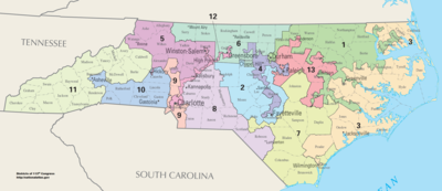
It sure as hell isn't like this, or anything like this. This gerrymandered piece of crapola is nothing but a capitulation to the political correctness of race race race, as demanded and commanded by the National Association of Always Complaining People and similar socialistic social clubs.
There are but a few, very basic principles to observe in dividing a state into Congressional districts. First and foremost, each district should have very similar populations, probably, when at all sensibly possible, no more than a ten per cent or so variance. That seems to be the consensus of my compatriots at The Red Cross Roundtable Meeting of the Mayors Pro Tem. This Federal court ordered dick headed ridiculousness that each North Carolina district have exactly 733,498 residents is absurd, and infinitely beyond absurd to the point that I don't think that there is an adjective in the whole of the English language to properly label it. Perhaps exilable or executable would be appropriate, as anyone who could come up with such an asinine idea is too stupid to live in my America. To consider anything other than population in determining districts is unconstitutional, in that it violates the equal protection clause.
Secondly, the districts should be laid out in a numerical order, going in one general direction, so that two follows one, three follows two and thirteen follows twelve. In North Carolina's case, it s a simple matter of beginning with the Outer Banks in the east and moving westward to the Tennessee state line. You sure as shooting don't have a 13th of 13 districts in the eastern third of the state, wedged between the 1st, 2nd, 3rd and 4th districts and you don't begin counting with three.
Next, and perhaps most importantly, districts should be designed to be geographically contiguous and drawn in accordance with and to such established parameters as county lines and city limits. In more densely populated municipal areas, existing physical and political designations can be used to determine districting. Entities such as fire and school districts, railroad lines and specific streets and roadways, or established neighborhoods and communities can be used. But to use race, political party affiliation, or any other socio-economic factor to determine district lines is just wrong. If a racial or other group wants to have its own congressional district, let enough members of that group get together and move, en masse to a specific geographical location, so that they have sufficient numbers in that geographical area to elect officials who will be beholden to the wants and wishes of that specific self-segregated group, rather than to an overall regional responsibility to a generally diversified general population.
 The lame ass Liebertarian party had such an idea in 2001. They called it The Free State Project.
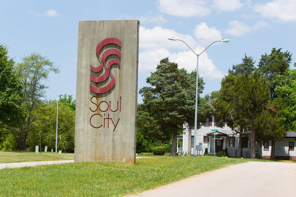
  We tried to accomplish such a thing, primarily for the Negroids, forty-some years ago here in North Carolina. It was called Soul City. It was a fourteen million dollar boondoggle. That's fourteen million 1970's dollars.
Then, there's the Mel Watt/Alma Adams 12th district. It stretches for over a hundred miles, encompassing parts of two, used to encompass parts of three distinct metropolitan statistical areas, with miles of it in various locations being no wider than an interstate highway with zero population. This district's boundaries are determined by nothing but race. Again, that is just wrong. It is self-requested and self-demanded segregationism.
I want to tangent for a moment to posthumously apologize to the African Negroids who were transported into slavery in 17th, 18th, and 19th century America. It has always been my wish that this country could have been founded and built without it. The Founders should have found a way. But remember, my contemporaries, that those African Negroids were quite often given over to European and North American Caucasoid slave traders by other African Negroids. If you want to harp on ancient, ancestral slavery, let's talk about the enslavement of my paternal ancestors.

 And if you want to talk about slavery in the present tense, we'll be talking mostly of Arabic and Persian Semitic Mullatoids and Eastern Mongoloids, and not European or American Caucasoids doing the enslavement.
 .


To the contemporary American Negroids, like Al Sharpton, Jesse Jackson and William Barber, I shall never apologize for the America in which they have lived. 'Reverands' all, these three men and others like them have all grown fat and wealthy in that America, about which they constantly and continually complain and criticize as a repressive and racist nation, while purporting to be the leaders of "Black America". At least Barber does seem to have a church he pastors.


Real American 'black leaders', or at least those who should be, and I hope, pray and believe are beginning to be recognized as such by more and more of the American Negroid population are real leaders by example, showing that great things can be accomplished by any American of any color, if the individual is willing to do the necessary work and accept the requisite responsibilities. Americans like Colin Powell, Herman Cain, Clarence Thomas, Dr. Ben Carson, Janice Rogers Brown and Micheal Williams have proven that relying on affirmative action and blaming 'Whitey' are not prerequisites for success.


As for you, 'Reverand' Sharpton, PLEASE keep you promise to leave the country if Trump is elected President. I'll help Hannity pay for your one way ticket to anywhere, as long as you do also promise to never return with your own personal brand of riot inciting racism. Same for any others with a similar wish. You can return to your ancestral Africa, where, without Caucasoid influence over the past few centuries, your contemporary cousins would still be trying to figure out how to cross the river and get over or around the mountain, as their (and your) ancestors were doing during the times of the American slave trade those centuries ago, when European Caucasoids were sailing the oceans, circumnavigating the globe. Instead of decrying and denigrating this great nation, quit your crying, assimilate, adapt to the culture of creative (but not crony) capitalism and make something of yourself, which is an impossibility as a 21st century African tribesman or woman. Now back to the point of this article.

Dividng this state into thirteen congressional districts is actually quite a simple matter, as long as basic principles of principle, priority and propriety are recognized as the only requisites, with no regard to the 3 R's of American politics; race, religion and to a lesser extent, revenue, only relative to economic theory. The twenty-one contiguous coastal and near coastal counties of Currituck, Camden, Dare, Perquimas, Pasquotank, Chowan, Bertie, Washington, Tyrell, Hyde, Pamlico, Beaufort, Gates, Hertford, Northhampton, Martin, Craven, Jones, Carteret, Onslow and Pender are home to 735,470 North Carolinians. That is a .000026884 deviation from the perfect population of 733, 498. That should be acceptable by any sensible measure. There's District One, commonly considered the northern coastal region.
The 2nd District should surely NOT be the assinine U shaped gerrymander that it presntly is, taking in unrelated populations in terms of regionality and resources. Somehow, I am in the 2nd district, living in northenmost Randolph County in the north central part of the state. Asinine. Absolutely asinine. The nine adjoining counties of New Hanover, Bladen, Brunswick, Columbus, Robeson, Scotland, Duplin, Sampson and Richmond in the state's southeastern coastal plain, along the ocean front and the South Carolina state line have a populaton of 742,206, less than two per cent over the target number. As a bonus, these counties share more than their contiguous nature. Their largely rural, agricultural commerce and shared riverway and highway connectivity to the state's only open ocean seaport also tie these counties and commuities together.
The Third Congressional District should of course be in that area of the state that is presently the 1st and 13th. Again, asinine. Absolutely asinine. This area of North Carolina is commonly called "Down East", lying between the capital city and the true coastal plain. The nine counties of that region, Lenoir, Wayne, Johnston, Wilson, Greene, Pitt, Edgecombe, Nash and Halifax have a combined popu;ation of 828,832. That is obviously beyond the desired skew. Herein lies the necessary consideration of splitting a county by means of city and town limits, communities and crossroads, etc., due to densely populated metropolitanism and suburban sprawl. Johnston County is the most popluous county amog the nine with 168,878 residents. Johnston County is an anomoly, in that the western most portion of the county, along the Wake County line, is basically suburban Raleigh and points east are "down east". Subtract the 16,116 residents of Clayton, the 2,277 of Wilson's Mills, the 4,292 of Archer's Lodge and the approximately 70,000 constituents living in the unincorporated communities of McGee Crossroads, Edmondson, Powhatan, Earpsboro and the connecting unincorporated, unidentified areas in that area to be part of the non-Raleigh Triangle district. And subtract the 3,311 or so inhabitants of Benson to be part of the Sandhills district, as the city does cross over the Harnett County line of that district. That leaves an approximate population of 742,836, which is well within acceptable range, with a one per cent deviaton.
The Sandhills 4th District includes the counties of Cumberland, Hoke, Harnett, Lee, Chatham, Montgomery, Moore, Stanly, the Johnston County town of Benson, and the Wake County portion of the town of Angier,with an approximate population of 709,484, a three per cent, acceptable, totally acceptable deviation.
Next districts to determine would be the Capital City and the non-Raleigh Triangle. We'll designate the 5th district to be the non-Raleigh Triangle, solely for the purpose of making the capital city #6, making it as close to center of the state as possible, in the one through thirteen numbering. District six would take in the in-town populations of Raleigh (including the 1,067 in Durham County), Cary, Morrisville, Apex, Holly Springs, Fuquay-Varina, Garner, Knightdale, Zebulon, Wendell, Wake Forest and the approximately 100,000 people living in the suburban areas between those cities and towns, for a constituency of approximately 812, 993. The non-Raleigh Triangle District 5 would consist of the approximately 85,175 people in more rural/agricultural Wake County, the approximately 92.691 in western Johnston County, as well as all of Franklin, Warren, Vance, Granville, Person, Durham and Orange Counties, minus the approximately 1,793 Mebane residents in Orange County, for a total approximate constituency of 803,854. Granted, both of those numbers are well over the perfect target number of 733,498, being at the very top edge of tolerance at just under and just over ten per cent. I consider this tolerable, as the basic, overall Triangle region is represented by two Representatives, and much of the population is comprised by a largely transient college/university student population of approximately 93.000, many, if not most, if not nearly all do not really reside in either district. And I'd bet that it would be a safe bet, that many of those students, especially UNC-CH and NCCU students vote absentee in their home district, wherever in America that that might be, as well as casting an in person vote at the local precinct polling place in Durham or Chapel Hill.


Sort of similar to NYC retirees voting for the cheater Charleses, Shumer and Rangel, as well as for whatever lunatic liberal, dumb mass Dummycrap/Demoncats they can in Florida, skewing that great state away from its true conservative composition..

But back to the primary point of this pontification. Next comes the Triad region of the state, with enough population to warrant two Congressional districts. Combining the populations of Alamance, Guilford, and Randolph Counties, adding the 1,793 or so Orange County Mebane residents and subtracting the 52 Kernersville citizens in Guilford, there is a constituency of 783,030, a two-thirds of one per cent deviation from optimal. makes that a superb 7th District. Triad 8 would be comprised of the populations of Caswell, Rockingham, Stokes, Forsyth, Davidson, Davie Counties and the 52 Kernersville resident in Guilford County, for a constituency of 719,603, which is off the mark by less than one per cent.
Moving on to the Charlotte metropolitan statistical area, Charlotte, with an in town population of 731.424, is about as perfect and easy as one could hope for, with a deviation of .0028275. The suburban Charlotte, or Metrolina district would consist of the remainder of Mecklingburg County, with a populaton of 187,844, along with the citizens of Union, Cabarrus, and Rowan Counties and the 294 town of Davidson residents in Iredell County, for a count of 705,819, a 3.7% deviation. So, there are districts nine and ten.
District 11 could be called the Outer Metrolina District, consisting of the remaining 159, 053 Iredell County residents, the 206.086 Gaston County residents, and the inhabtants of the'Presidental' counties of Cleveland, Lincoln, Rutherford and Polk. Rutherford was actually named for a Revolutonary War general, but of whom do you think when you hear the name Rutherford? President Hayes or some unknown brigadier general whose primary fighting was against the Cherokee and not the British? The one time that he was engaged with the British, at Camden, he was captured. Reardless, that gives District 11 a total population of 629,802, a generally unacceptable deviation of 14%. But for the entire Metrolina metropolitan area, the difference is only nine per cent, which is within tolerance level of ten per cent.
The last two districts to be divvied could be identifed as the north and south foothills and mountains. The southern foothills and mountains twelfth district consists of Cherokee, Clay, Macon, Graham, Swain, Jackson, Haywood, Transylvania, Buncombe, Yancey, Madison, McDowell, Mitchell, and Henderson Counties, with a population of 670,968, an eight and a half per cent miss of the mark. The northern foothills and mountains 13th district of Yadkin, Surry, Wilkes, Alexander, Caldwell, Catawba, Burke, Alleghenny, Ashe, Watauga and Avery Counties, is populated by 654,228 folks, for a deviation of eleven per cent. Together, the two district region has an overall deviation of just under ten per cent. I justify the low resident to Representative ratio for this region of the state, based on several factors. The terrain and topography, along with the large, multi-county land mass of each district makes it dubiously more difficult for a Congressperson to get around his or her district. And the westernmost part of North Carolina has special and specific resources and requirements, such as tourism and transportation, as well as unique and unified population pockets.
It's not perfect, but it's closer to perfect than the poop and poppycock of the present and the Complaining People's preposterous proposals.
No comments:
Post a Comment